Wednesday, April 10, 2024

MLK's One-way to Two-way Conversion: 6 Lanes or 5?

Lansing's Martin Luther King Jr Blvd has been the subject of much discussion recently, with the City's planned one-way to two-way conversion of downtown. In order to convert the downtown streets to two-way streets, MLK will need to be reconfigured. As part of the reconfiguration, a proposal includes changing MLK from a 6- and 7-lane road with a median, to a 4- and 5-lane road with medians along about half of its length.

The city sent a public notice to nearby neighbors with some description of what this could look like. Here is Lansingography's adaptation based on the diagrams and text in the letter (text below):

Option 1: 6 Lane Roadway with Modifications

Maintain the existing roadway, which consists of 6 travel lanes, median crossovers and left and right turn lanes.

Modifications needed to accommodate two-way traffic at Ottawa Street and Allegan Street would be:

1. Construct a southbound left turn lane at Ottawa Street.

2. Increase the size of the curb radii at the corners of northbound Martin Luther King Jr. Boulevard at Ottawa Street and Allegan Street to accommodate right turns. With this configuration, westbound Allegan Street traffic would need to use the crossover at Michigan Avenue to turn left onto southbound Martin Luther King Jr. Boulevard.

This design accommodates current (2024) traffic volumes.

Option 2: 5 Lane Roadway with Medians and Pathway

Reconfigure the roadway to two lanes in each direction with a center turn lane and medians. Modifications needed to accommodate two-way traffic at Ottawa Street and Allegan Street would be:

1. Move the east curb line of the southbound roadway to the east between Kalamazoo and Ionia Streets to accommodate two lanes in each direction with a center turn lane.

2. Modify median between Ionia and Ottawa.

3. Add medians between Michigan Avenue and Ottawa Street and between Chelsea Avenue and south of Kinsley [sic] Court.

4. Add a push button activated flashing beacon for Michigan Avenue pedestrian crossing.

This configuration would enable direct turns at Kalamazoo, Allegan and Ottawa Streets and would result in the addition of 1 1⁄2 acres of green space on the east side of the roadway. A 10-foot wide pathway would also be constructed on the east side of the roadway.

This design would accommodate current (2024) traffic volumes and increased volumes resulting from a return to in person employment in downtown to pre-pandemic levels plus additional growth.

The city is still collecting feedback on these designs at the MLK website (look for "Electronic Comment Form").

Sunday, March 3, 2024

2024 Primaries: Trump vs Haley, Biden vs Uncommitted

Last week's primary: of the motivated folks who showed up, who was on team Haley vs team Trump? Who was on team Biden vs team Uncommitted? Here are four maps that show the proportion of votes going to each candidate. A darker color means more votes (of total votes cast in that primary) went to that candidate.


Election results from the Ingham County Clerk's office. Water, streets, and greenspace © OpenStreetMap contributors.


Saturday, February 24, 2024

Lansing's Martin Luther King Jr Blvd: How a Street Swallowed a Neighborhood

MLK Blvd: From Neighborhood to Street

It might be hard to imagine now, but Martin Luther King Jr Blvd used to be a regular neighborhood street, lined with single family homes, apartments, and storefronts. Now, downtown, it is a city highway that spans almost a full city block in certain areas with its six to eight lanes and a wide median for grass and trees.

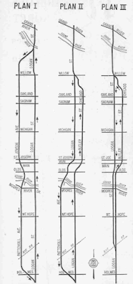
For a long time in Lansing history, Martin Luther King Jr Blvd was named Logan Street. Like many downtown city streets, it had houses, flats, mixed use, and shops along its length. And like many cities in North America, there was a movement to extend highways through their downtowns in the mid-1900s. The State Highway Department (which would become today's Department of Transportation) proposed and successfully enacted widening of Logan, part of M-99, several times since the 1960s. In 1961, the city and the state were weighing three proposals to route car traffic through Lansing. Here's a diagram from the Lansing State Journal, in 1961.

three plans to enact a highway in Lansing
Three plans for a highway through Lansing. Lansing State Journal archives (19 Nov 1961)

The plans were contentious, and some people in the city of Lansing voiced concerns and opposition. There are letters to the editor in the LSJ going years back from people in Pattengill and the West Side neighborhood asking the state not to bulldoze their neighbors' homes. (Lansingography has discussed other neighborhoods being demolished to build highways, I-496 is another)

Eventually, a variation on Plan 3 above went forward. Logan had been widened several times over the years already. In the 1980s, the Logan Corridor was wrapped into the Capitol Loop project, and in 1988, MDOT began interviews with homeowners for appraisal, purchase, and relocation services. An early estimate of 60 homes would need to be demolished (the number was closer to 150 homes and 300 total buildings). In 1989, the LSJ reported that MDOT would start construction in the summer of 1991, which they did.

According to Lansing City Council minutes, 1989 was the same year that Logan was "codesignated" as MLK. In 1994, the signs saying Logan were officially dropped and Martin Luther King Jr Boulevard served as a throughfare through our city.

Bye, Bye, Busy Bee Market

The local homes and businesses were closed, and some were relocated. A doctor's office, the Busy Bee Market, Calhoun's Takeout, Hazel's Salon, and Frank's Grocery store all closed, to be replaced with a street for people to drive through Lansing.

There are letters to the editor in the LSJ from residents of the West side neighborhood who were concerned about being disconnected from the rest of Lansing and from the amenities downtown. In addition to the commercial areas on Logan and Butler being demolished, there was a raised crosswalk over Logan that was being taken down. Pedestrians would now need to cross the street at car level.

Lansing Looks Back to Move Forward

The City of Lansing now owns the strip of land that was Logan/Martin Luther King Jr, the State of Michigan owns the blocks that were demolished. The City has proposed restoring MLK to approximate what it was in the 1950s: a car thoroughfare with sidewalks along its length. Instead of six to eight lanes that curve through the Butler blocks, it would be straight through downtown from Ionia to Kalamazoo. The plan is online on the City's website. Lansing Public Service is holding a community meeting Thursday, February 29, 2024, from 4-6 pm at Letts Community Center, to cover both this and the sewer separation project.

Here is what the 1950s map looks like superimposed on our current road layout, with the Lansing proposal below it (areas in neon green will be returned to the State of Michigan).


The following numbered diagrams are from the community meeting; each intersection will be configured with slipways or pedestrian medians.


When there is no longer a highway running through our downtown, what could we use that space for? Will we make downtown whole?

Saturday, February 17, 2024

Lansing's Downtown Parking By Use

I've written about parking in Lansing before (and our ignoble award), but in this map (created by Lanstronaut Cedar500) of the Capitol Complex's parking divided by use and restriction is currently being discussed on Lansing's subreddit.

Even though Lansing has a lot of land reserved for parking downtown, a lot of the parking is not available to the average patron or visitor. In Lansing, parking lots are considered undeveloped and therefore do not generate  taxes for the city. They also have the effect of making amenities further apart from each other, making an area less walkable. A lot that is reserved 24/7 for AF or the State of Michigan sits empty in the evenings and weekends when patrons might want to use it to go to a show at Grewal, visit a restaurant, do a pub quiz and some shopping downtown.

Sunday, February 11, 2024

Where Are The Pączki in Lansing, 2024 edition

Ah, pączki day is almost here. This year, in 2024, Pączki Day is Tuesday, February 13. Looking for a pączek? (That's the singular form of the pastries we call pązcki.) Lansing has a large number of locations where you can acquire these tasty treats. Major props to Quality Dairy for not only preparing a passable pączek but also owning the landscape! I'm a fan of their raspberry pączki. Yum! This year they added pineapple upside down pączki. Thoughts?

Our family makes 'em but if you gotta get 'em from the store, where do you go? Here are some suggestions! Smacznego! (Bon appetit!)

Last year, I also calculated the catchment area of pączki in Lansing, if you are curious. Still hoping to get a walkable pączki neighborhood in Forest View and St. Joseph Park—maybe someday!


Monday, November 27, 2023

How Old Are Lanstonauts?

How old is the typical Lanstronaut? The census has the median age or a citizen here at 33.9; when you include the Lansing Metropolitain Area, that number is in the 40s.

When mapped across our neighborhoods however, patters emerge. younger folks take up the most space at MSU, obviously. Gen Z and Millennials can also be seen in the apartments near Forest View, as well as many places downtown. And like many cities, the further from the urban core, the older the demographic.

What patterns do you see?


Data from the ACS (ages) as well as OpenStreetMap contributors (streets, water and greenspace). See an error? Maybe you want to become a contributor and make it better for the next person.

Monday, November 20, 2023

Most Valuable Land in Lansing: Taxable Value by Area

 In Lansing, 33% of our city's budget is made up of property taxes. Where does that money come from?

City infrastructure is expensive: roads, pipes, wires, and lines cost by distance, so suburbs with far apart houses often rely on medium- or high-density corridors or a downtown to offset the cost of building infrastructure to reach them. 

Where are the areas that are the most valuable to our city per sq/m? The Michigan corridor is very apparent when taxable value per acre is mapped. You can also see the new developments South of Frandor as well as Washington Square.

Property tax "holes" are visible as well: things that do not generate property taxes such as state buildings, schools, and surface parking lots.


These data came from the City of Lansing open data portal. Thanks!