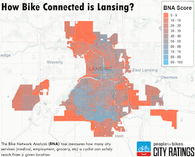
Every year, the organization People for Bikes rates cities based on how bike friendly they are. The organization rates small, medium and large cities based on their several factors, including safety, ridership, network, reach, and acceleration. Michigan's medium and large cities are ranked below; Lansing came in third in Michigan this year, however our overall rating (36 out of 100) is still very low (84th percentile overall):
Lansing has made incremental improvements over the years (two years ago our network was rated 30), but we have a long way to go to as a city and a state to be bike-friendly cities.
You can read Lansing's full report here.
One of the biggest factors that influences a rating is the connectivity of a city, that is, can a person on a bike reasonably make it to core services (like medial or grocery), opportunities (a job or school), recreation, retail, and transit. This is a take on the idea of the 15 minute city, but instead asks the question: in ten minutes, how far can a cyclist go in your city?
Connections can be protected bike lanes (Lansing has none), specific pedestrian infrastructure (the River Trail network), and low speed roads (like the residential network). The analysis cuts off connectivity at high speed streets that do not have pedestrian or cycling infrastructure, like Aurelius, Saginaw, Cedar etc.
Lansing's connectivity analysis is mapped below: this is what happens when we place that network over needs and services, such as education, health, recreation and so on. Areas that are bright blue are areas that have strong connections to services, and red areas are cut off from these services. Lansing's best areas top out at around 65 points, but there are a great many areas that are not connected at all.


No comments:
Post a Comment